
The Southern Oregon Wildlife Crossing Coalition (SOWCC) is a broad-based partnership advocating for safe wildlife passage and reduced wildlife-vehicle collisions in the Siskiyou Summit area of I-5 between Ashland and the California border. To accomplish this goal, we are working towards creation of a network of wildlife crossings. Our first project is construction of the Mariposa Wildlife Overcrossing at Mile Post 1.7 just north of the Oregon/California border. This project includes fencing that will help funnel wildlife to the overcrossing. Our second project is construction of a wildlife-friendly bench for wildlife travel under I-5 at the Mt. Ashland Exit. Both projects are currently being monitored by faculty and students at Southern Oregon University to determine pre-project conditions.
The Oregon Wildlife Foundation is proud to serve as the fiscal sponsor of SOWCC.
For More Information
Merkley, Wyden Unlock Critical Federal Funding for I-5 Wildlife Crossing in Southern Oregon
Federal funds will support construction of an I-5 overpass for wildlife to safely cross
LandLine: Bridge would allow wildlife to cross busy interstate
Oregon gets more than $30 million from federal government to build overpass wildlife crossing on I-5
KS Wild Side: Wildlife overpass slated for construction at an ecological crossroads
Wildlife crossing in Southern Oregon will be first on I-5 between Mexico and Canada
How the new wildlife crossing over I-5 will help delicate Oregon ecosystem
ODOT using $33 million grant to build first wildlife crossing over I-5
ODOT to build first wildlife crossing over I-5 with $33M federal grant
ODOT getting $33M in federal funds for wildlife crossing south of Ashland
Oregon Department of Transportation: Project-Details : Projects : State of Oregon
The Oregon Connectivity Assessment and Mapping Project (OCAMP) – Oregon
Funding in place for wildlife crossing with key SOU role - SOU News
How the new wildlife crossing over I-5 will help delicate Oregon ecosystem - oregonlive.com
Wildlife Wins: I-5 gets first-ever overpass for animals - TheTrucker.com
Conceptual Design Report Completed
In November 2022, the River Design Group and Samara Group completed the Southern Oregon Wildlife Crossing Project Conceptual Design Report. In cooperation with the Oregon Department of Transportation (ODOT), SOWCC selected the Mariposa Preserve site, at milepost 1.7, as the priority location for an overpass. This site is on federal lands inside the Cascade-Siskiyou National Monument and also showed the highest biodiversity of any site between Ashland and the California border. ODOT amended its Statewide Transportation Improvement Plan (STIP) to include the Southern Oregon Wildlife Crossing Project, which is necessary to allow the project to apply for federal funding opportunities.
During the 2021 Oregon Legislative Short Session, Representative Ken Helm sponsored a bill that allocated $7 million to ODOT for wildlife crossing design and construction. ODOT Region 3 has been authorized to draw on a portion of this funding for the engineering design phase of this project. ODOT, with support from SOWCC, will apply to the new Federal Wildlife Crossing Pilot Grant program for additional planning and construction funding. The Oregon Wildlife Foundation has received $400,000 in Congressionally Directed Spending from Oregon’s U. S. Senators Merkley and Wyden that will help ODOT design the funnel fencing portion of the project.

-

Who We Are
The SOWCC is composed of state and federal agencies, land trusts, hunting conservation organizations, environmental organizations, Southern Oregon University, and other local stakeholders.
-

What We're Doing
The immediate goal of the SOWCC is to identify and establish one or more safe wildlife crossings along I-5 between Ashland and the California border as part of a future network of dedicated over and undercrossings in the area.
-

How We're Doing It
The SOWCC engages in education, outreach, coordination, and fundraising in partnership with our primary nonprofit partner, the Oregon Wildlife Foundation.
What Is the Issue?
Interstate 5 in southern Oregon is a vital part of our state’s transportation system. And because it passes through one of Oregon’s primary wildlife migration corridors, it can also be dangerous.
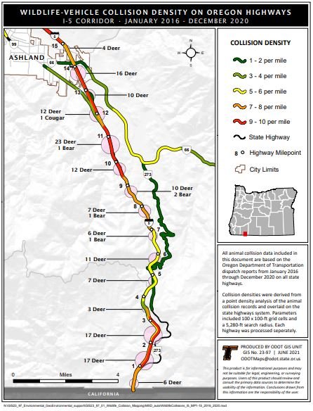
Wildlife-Vehicle Collisions (WVCs) are increasing and causing extensive property damage and endangering human life. This is a critical public safety issue and a wildlife tragedy. The Oregon Department of Transportation (ODOT) collects data on vehicle collisions with large animals. There are approximately 7,000 such WVCs in Oregon annually.
Each WVC involving deer averages $6,617 for emergency response, towing, repairs and medical expenses. For elk, each collision averages $17,483 for repair costs and injury expense. Significant portions of this stretch of I-5 are in ODOT’s high-risk “red zones” for WVCs.
Wildlife-Vehicle Collisions and Crossing Facts
See full report courtesy of Wildlands Network here
Human Safety
Oregon drivers face a 1 in 180 chance of hitting an animal, which is the highest rate of West coast states.
In 2020, ODOT recorded 5,997 collisions with large-bodied wildlife, with deer and elk collisions accounting for the vast majority, and for every recorded collision, there are likely 2 additional collisions that go unreported.
From 2014 to 2018, ODOT reports that wildlife collisions caused an average of 2.2 casualties and 453 injuries per year.
Economic Costs and Benefits
In 2021 dollars, the average cost of a deer collision is $8,530 and an elk collision costs $22,539, accounting for vehicle repairs, injuries, towing and emergency crews, value of the animal, and carcass removal and disposal.
With this average cost, deer and elk collisions in 2020 in Oregon cost roughly $53.4 million.
The Lava Butte Wildlife Crossing Project on Hwy 97, saw an 80% reduction in deer collisions within its first year. Studies show that wildlife crossings that guide animals over or under highways reduce wildlife-vehicle collisions by up to 97%.
Environmental and Climate Resilience Benefits
Oregon mule deer populations have been in a steady decline for years, and while many factors contribute, reducing collisions and increasing wildlife movement can help alleviate pressures mule deer face.
2020 polling found 75% Oregonians support additional public funding for wildlife crossing infrastructure.
The Cascade-Siskiyou is renowned for its biodiversity and provides ecological connections among the Coast Range and Klamath Mountains to the west, and the Cascades and High Deserts to the east. Wildlife crossings along I-5 would restore the ecological connections currently severed by the freeway.
Oregon Support for Wildlife Crossings
86% of Oregonians support building wildlife overpasses and underpasses in concentrated migration areas, with 57% strongly supporting, and maintaining open corridors for wildlife to migrate is supported by 88% of Oregonians.
Expanding culverts and bridges to allow for aquatic and terrestrial passage not only benefits wildlife, but also makes our infrastructure more resilient to climate change and extreme weather events, such as flooding.
Oregon lags behind other western states in constructing wildlife crossing infrastructure, and making state funding available can be leveraged to make Oregon projects more.
Meet the Feasibility Sites
Eight sites are proposed for further investigation as potential wildlife crossings across I-5 between Ashland, Oregon (Mile Post 14), and the California Border (Mile Post 0). In their existing conditions, some sites provide limited wildlife crossing opportunities, but all could benefit substantially from fencing, habitat improvements, reengineering or replacement of existing culverts and bridges. Two sites are potential overpass locations. The sites are described below, from north to south.

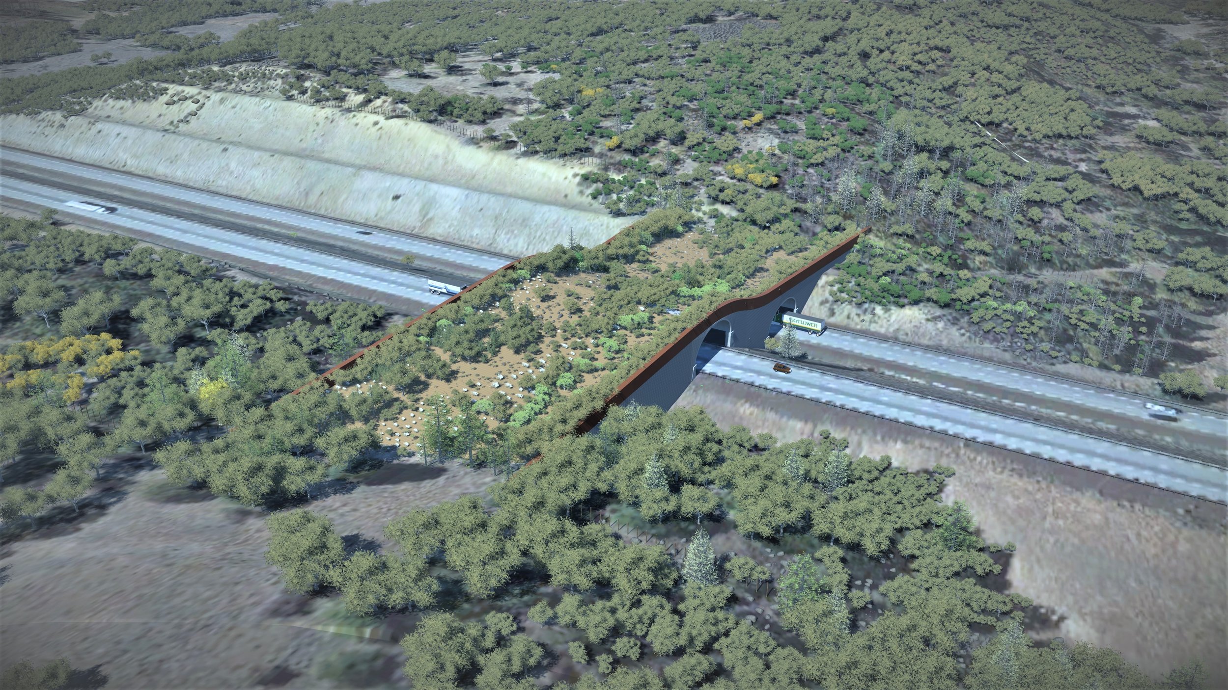
Conceptual design of the Mariposa Overcrossing structure at Mile Post 1.7
Site 1
Neil Creek
Mile Post 10.4
This is a combination of a small box culvert that Neil Creek flows through and under I-5; as well as a small bridge undercrossing that provides road access (Neil Creek Road) to private homes and Rogue River-Siskiyou National Forest lands west of the Interstate. Under many flow conditions, Neil Creek Culvert currently provides a velocity barrier to fish trying to ascend the creek. Steelhead, cutthroat trout, sculpin, and potentially, coho salmon occur seasonally in Neil Creek and utilize upstream portions of Neil Creek on the national forest for spawning. The box culvert was modified in 2018 by placing baffles in the culvert bottom to disrupt flow and increase the likelihood of fish passage during spring and summer. It is unknown to what extent wildlife currently use the adjacent bridge undercrossing.
Site 2
Barron Creek
Mile Post 8.75
An existing 134-foot long, 4-foot diameter corrugated metal pipe culvert conveys Barron Creek under the highway (west to east) at this location. There is currently no overcrossing structure here. The highway cuts through the adjacent hills to the south which lend themselves to a potential overcrossing (aka a land bridge restoring the ridge lines). The proximity to the creek is likely to attract many species to this location. Barron Creek has been selected as the northernmost location for a wildlife overpass.
Site 3
Wall Creek
Mile Post 8
This site consists of two potential wildlife crossing opportunities, a railroad bridge overcrossing and a small culvert undercrossing. Wall Creek is a small but perennial stream that provides habitat for coastal tailed frogs, a state of Oregon Conservation Strategy Species. An important wildlife area, Ogden Hill (Rogue River-Siskiyou NF), is immediately to the west of this site. Currently, the existing approximately 4-ft wide Wall Creek culvert is gated by a series of rail sections, presumably to prevent debris accumulation at the culvert entrance. The railroad bridge owned by the Central Oregon and Pacific Railroad is lightly used by trail traffic and appears to have numerous wildlife trails leading to and across the bridge.
Site 4
Mt. Ashland Exit
Mile Post 6
This exit allows vehicle access to the ski area and nearby resort. Existing bridges provide vehicle access under the interstate. The bridges also provide some wildlife crossing opportunities, which could be improved by construction of a “wildlife bench” under the existing bridges that is shielded from traffic by plantings, logs and boulders. Wildlife use under the bridges is currently being monitored by faculty and students at Southern Oregon University.
Site 5
Siskiyou Summit
Mile Post 5
A slightly larger, but still small (approx. 5-ft diameter) existing culvert under the interstate likely provides some wildlife crossing opportunities (with light visible from one side to the other), which presumably could be improved with a larger culvert or bridge overcrossing and fencing. This site is being monitored by BLM for wildlife use.
Site 6
Bear Gulch
Mile Post 2.5
A large culvert, 6-8 foot diameter runs under I-5 with good line of site to other side. Currently used as undercrossing by coyotes and bobcats. Functional crossing but could be improved.
Site 7
Mariposa Preserve
Mile Post 1.7
A larger, but still relatively small culvert, approximately 5-ft diameter, carries perennial water under I-5 at this location. The stream and existing relatively dense riparian vegetation attracts wildlife but the existing culvert is likely too long and too narrow for their use. In addition to deer, bear, and other large animals, this area is frequented by elk. The creek has been identified by BLM as a high priority beaver reintroduction site and an improved undercrossing could connect significant portions of the Cascade-Siskiyou National Monument, which is located both to the east and west of the interstate. Mariposa Preserve has been selected as the southernmost location for a wildlife overpass.
Site 8
South Culverts and South Overcrossing
Mile Post 0.3
There is currently no overcrossing structure here. This location may be suitable for an overcrossing because of the existing cuts with sufficient width and elevation to span over the traffic lanes, being surrounded by publicly owned lands, and the distance from Highway 273 to the east. The species assemblage is similar to that observed and expected at the Mariposa Preserve site. Lands immediately adjacent to the ODOT right-of-way are publicly owned on both sides.
Coalition Members
The Southern Oregon Wildlife Crossing Coalition includes representatives from Oregon Department of Transportation, Oregon Department of Fish and Wildlife, Bureau of Land Management, US Fish & Wildlife Service, Office of Representative Pam Marsh-HD 05, Southern Oregon University, Oregon Hunters Association, Backcountry Hunters & Anglers, Soda Mountain Wilderness Council, Southern Oregon Land Conservancy, Pacific Forest Trust, Trout Unlimited, Rogue Valley Audubon Society, KS Wild, Wildlands Network, Selberg Institute, SC Wildlands, and Oregon Wildlife Foundation.

Major Donors
Thank you to the numerous individuals and organizations who have made this project possible.
Olseth Family Foundation
Oregon Watershed Enhancement Board
Selberg Institute
U.S. Fish and Wildlife Service
Bob and Susie Givens
Oregon Wildlife Foundation
Oregon Hunters Association
Backcountry Hunters and Anglers
KS Wild
The Oregon Conservation and Recreation Fund
The Carpenter Foundation
Rogue Valley Audubon Society
Greenfield-Hartline Fund